A comprehensive plan is a document that contains a shared community vision for where to grow and what to protect in the future. The Albuquerque/Bernalillo County Comprehensive Plan (“ABC Comp Plan”) is primarily a land-use plan, providing policy guidance about where growth is appropriate and what form it should take.
Most comp plans look at existing conditions and trends and then set out a vision for future growth, goals and policies grouped by topic, and implementation steps to set priorities for action.
Most importantly, the policies and action items in a comprehensive plan guide the development of regulations related to growth and development (such as zoning) to help achieve the community’s vision for the future.
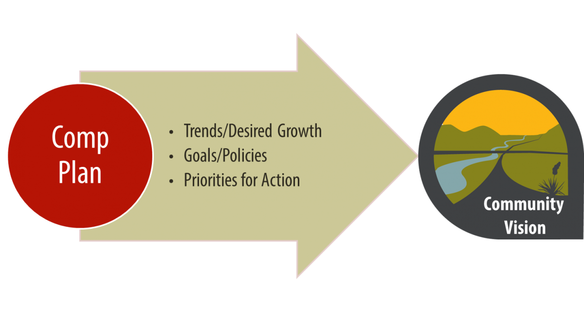
The Comprehensive Plan looks at recent demographic and market trends and indicates where growth is most appropriate and what to protect. The Comp Plan is a policy document used to guide future zone changes and recommend implementation and Capital Improvement Project (CIP) funding priorities for City/County decision-makers and departments.
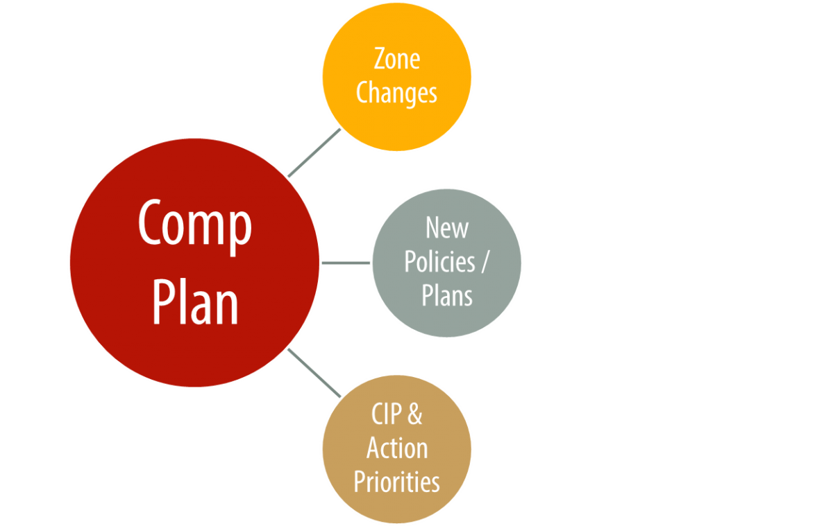
How does a Comprehensive Plan relate to the Zoning Code
One purpose of a comprehensive plan is to inform the zoning code: the zoning code is the regulatory tool used to implement the goals and concepts from the comprehensive plan that apply to land use and development.
In other words, a comprehensive plan contains the vision, goals and policies for growth and development, and the zoning code contains the regulations to implement that vision.
A comprehensive plan is generally not used in day-to-day decision-making for projects that have established zoning, while the Zoning Code is.
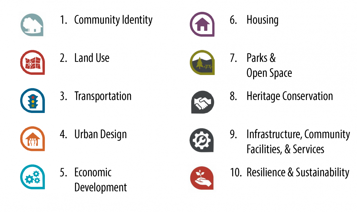
The 2017 Comp Plan includes goals and policies for the following topic areas, described as "Elements" in the Plan, each with its own chapter.
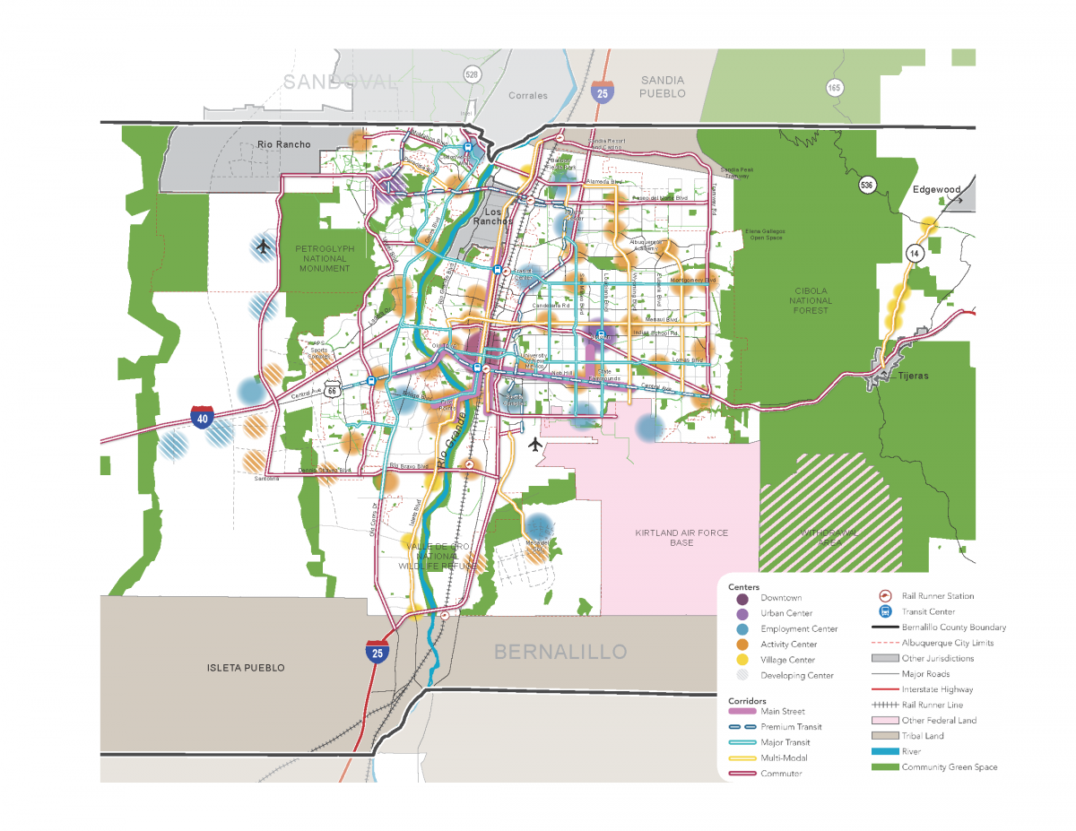
The community vision in the ABC Comp Plan is that growth -- if it happens -- is most appropriate in centers that have jobs, services, community facilities, and infrastructure within walking and biking distance of residences. These centers of activity should be connected by corridors that offer safe options to get around by walking, biking, driving, or taking transit. Taken together this approach to growth is referred to as the Centers & Corridors Community Vision.
The 2017 update confirmed widespread support for the Centers and Corridors vision, which was first adopted into the Comp Plan in 2001 and updated in 2013. The 2017 update continues on the Centers and Corridors vision, but revises down the density and intensity described in most centers, with three exceptions:
- Downtown is identified as its own Center, that is to be the most urban, walkable, and intense of all the Centers.
- Two Urban Centers - Uptown on the east side and Volcano Heights on the west side - are to be the next most urban, walkable, and intense of the Centers.
See also:
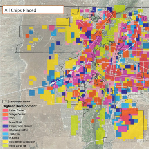
- Visioning Results from Visioning Workshops in May & June 2015 (i.e. table maps)
- Survey & Polling Results
Prior to 2017, the City established these Development Areas in the Comprehensive Plan: Central Urban, Established Urban, Developing Urban, Semi-urban, Rural, and Reserve. These areas were not particularly relevant or effective to guide new development, so Areas of Change and Consistency were adopted to replace them with something more relevant and effective.
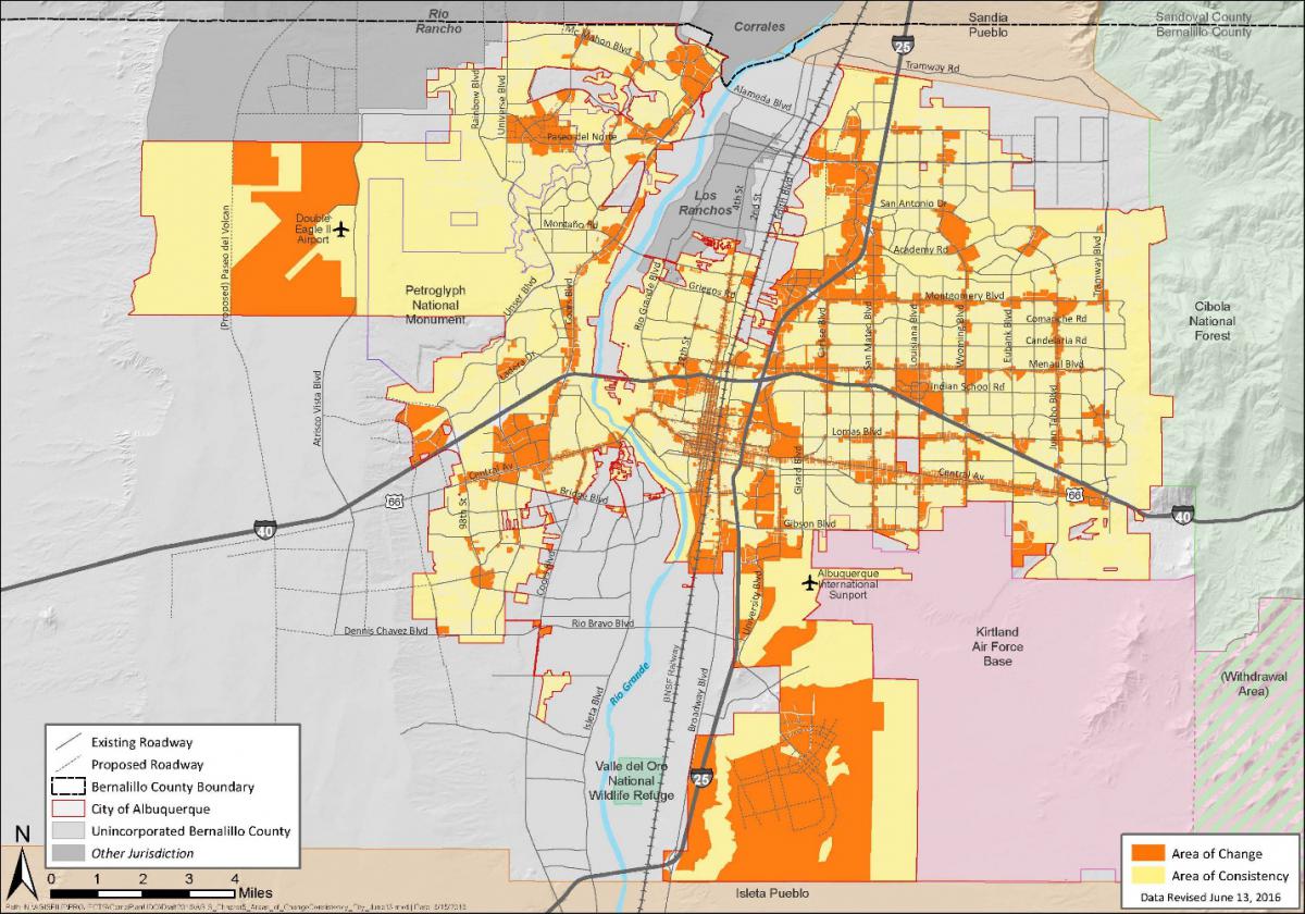
Change areas (shown in ORANGE in the map below) include Centers and Metropolitan Redevelopment Areas with adopted MR Plans, in addition to corridors served by high frequency or high-capacity transit. We think Areas of Change and Consistency may be an effective tool to implement Centers and Corridors and protect existing neighborhoods.
The intent of Areas of Change is to focus or direct development to areas with infrastructure that can support additional density, etc. while protecting single-family neighborhoods (as Areas of Consistency, shown in YELLOW below). This will help accommodate new residents and jobs in the existing built area of the city where it can be served by transit (as an alternative to sprawl); help support redevelopment of commercial corridors (providing services, stores, etc. to neighboring communities); and protect and enhance existing single-family neighborhoods.
Areas of Change are parcels with existing commercial and/or higher-density residential entitlements. The designation in the Comp Plan would not result in major changes to entitlements, but it might limit the scale and design of new development to be more respectful of the scale and character of nearby existing single-family neighborhoods.
The Comp Plan policies would guide development requiring a zone change, and regulations in the IDO (i.e. zoning) would limit the scale and enhance buffering for development or redevelopment abutting an Area of Consistency as an added protection for single-family neighborhoods.
Review and Approval Process
The 2017 ABC Comp Plan is now effective within the City of Albuquerque. Bernalillo County has not yet sent the updated Plan through its review and approval process.
The project team thanks everyone who participated in the process to update the plan that will help protect our unique and vibrant neighborhoods and open spaces and keep Albuquerque a beautiful place to live, work, play, and learn for the next 20 years.
This Plan is a step forward for all of us, and it would not be as good as it is without the rigorous review and engagement from residents, property owners, developers, design professionals, and staff from City and County departments, as well as other agencies. The project team thanks everyone who submitted written comments, came to testify at hearings, and asked questions at office hours, meetings, or by email.
- The updated ABC Comp Plan was heard by the City's Environmental Planning Commission in August/September 2016.
- The updated ABC Comp Plan was heard by the City Council's Land Use, Planning, & Zoning Committee in November/December 2016.
- The updated ABC Comp Plan was heard 4 times by the full City Council - twice in January 2017 and twice in March 2017. Council adopted the updated ABC Comp Plan on March 20 via Resolution 16-108. The Mayor signed on April 7, the City Clerk published it, and the Plan became effective on April 12, 2017 for property within the City of Albuquerque.
- The 2017 ABC Comp Plan will now be sent through Bernalillo County's formal review and approval process, with review first by the County Planning Commission and then the County Board of Commissioners.
ABC Comp Plan - Adopted March 20, 2017 and Enacted April 12, 2017
- Full document (Warning: Large File Size with lower-resolution graphics than in the chapter versions below)
- Chapter 1: Introduction
- Chapter 2: Factors of Growth & Development
- Chapter 3: Vision
- Chapter 4: Community Identity
- Chapter 5: Land Use
- Chapter 6: Transportation
- Chapter 7: Urban Design
- Chapter 8: Economic Development
- Chapter 9: Housing
- Chapter 10: Parks & Open Space
- Chapter 11: Heritage Conservation
- Chapter 12: Infrastructure, Community Facilities, & Services
- Chapter 13: Resilience & Sustainability
- Chapter 14: Implementation
- Appendix
ABC Plan Integral - Español - Capítulos 1 y 3
- Capítulo 1 - Introducción
- Capítulo 3 - Visión
- Capítulos 1 y 3 - Introducción y Visión
Frequently Asked Questions
- ABC-Z
- ABC Comprehensive Plan
- Updating the Comprehensive Plan - Public Engagement summary
The updated plan continues the vision adopted in the Comp Plan in 2001 to guide growth to Centers and Corridors that are mapped in the Plan. The goals and policies from the 2013 Plan that had not yet been accomplished were carried over. (See the Policy Matrix for where adopted policies were incorporated in the updated Plan).
New goals and policies were drafted based on the values, issues, and suggestions from the public engagement process. Narrative content, which had not previously been updated since 1988, was updated to reflect recent trends, challenges, and strategies. Implementation actions were added to policies and reflected in a Policy Action matrix in a new Implementation chapter based on public input and coordination with implementing departments in the City and County.
The goals and policies in the Comp Plan were forward-looking when they were drafted in the 1970s, updated in the 1980s, and reshaped in the 2000s, when the Centers & Corridors vision was added to the plan. These policies have been clarified and strengthened with implementation actions. Land use and transportation policies, in particular, have been more closely coordinated with regional transportation plans and City and County departments responsible for transportation.
Goals and Policies
- There has been growing awareness of the importance of closely coordinating land use and transportation to improve the public realm and help achieve the Centers and Corridors Vision, so those sections have been closely analyzed and updated to strengthen their effectiveness.
- Goals and policies from adopted plans for smaller geographic areas - Area Plans and Sector Development Plans - have been incorporated into the Comprehensive Plan to extend the protections they provide to all communities and to make sure they can be more effectively implemented and assessed every 5 years as a part of a regular cycle of Comp Plan updates.
- Other goals and policies, such as those for Economic Development and Heritage Conservation, have been assessed and updated to reflect community priorities and commitments from implementing departments .
Implementation
This Comp Plan update provided an opportunity to coordinate how City/County departments will help implement the Comp Plan and its Centers & Corridors vision. This chapter now includes:
- a Policy Action Matrix that identifies roles and responsibilities for implementing departments, progress, and timeline for implementation,
- Performance Metrics that can be tracked over time to measure progress toward implementation, and
- Strategic Actions that can be taken to catalyze progress toward implementing the Centers & Corridors vision.
Comp plans need regular updating as circumstances change and community goals evolve. The Albuquerque/Bernalillo County Comprehensive Plan was originally adopted in 1974, overhauled in 1988, and amended in 2001 to establish the Centers & Corridors vision for how best to grow over time. Since then, there has been increasing awareness of how important it is to coordinate land use and transportation to improve quality of life for all citizens. Comp Plan policies have been updated and closely integrated to help achieve the community’s Centers & Corridors vision.
The Comp Plan was part of a complex structure of tiered plans that are difficult and in some cases nearly impossible to implement or enforce within the City. The 2017 update simplified this structure to make the plan easier to use and more transparent in how its policies relate to City development regulations, particularly the codes for subdividing and zoning land and the Development Process Manual, which guides the development of streets and infrastructure.
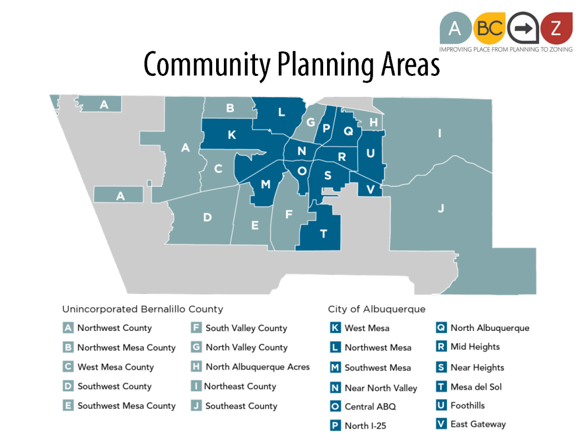
The Comp Plan will now be updated every five years, after Long Range Planners in the Planning Department work with stakeholders in each of the City's 12 Community Planning Areas in the city to assess how well policies and regulations are working in each area to guide desired development and recommend changes.
See also "How does ABC-Z propose to improve public engagement with the City?"
The Long Range planners in the City's Planning Department and staff from Council Services led the update effort, with support from consultants Fregonese Associates out of Portland, Oregon.
Fregonese created software called Envision Tomorrow that creates a city-wide model of land use, including building footprints, and transportation networks that can be used to test the effectiveness of existing and proposed land use and transportation policies and regulations against market conditions. This model will supplement scenario planning done by the Mid-Region Council of Governments in its recent Futures 2040 efforts to update the Metropolitan Transportation Plan.
Yes. Catherine VerEecke, with the County’s Planning and Development Services Department, and Richard Meadows, with the County's Public Works Department, were involved throughout the process to update the Comp Plan. County staff from multiple departments helped update and review narrative content, goals/policies, and most importantly, implementation actions.
Now that the City has adopted the 2017 update, the County will send the Plan through its review and approval process to adopt the revised Comprehensive Plan.
At this time, the County is not anticipating changing its zoning code or adopting the City's Integrated Development Ordinance, although there may be future opportunities to adjust zoning and/or sector development plans in the County as the need arises.
Since 2001, the City and County have shared the Centers and Corridors vision – setting out where additional growth is preferred so that we can best plan to serve new and existing residents and protect neighborhoods and open space from needing to absorb expected growth.
The Comp Plan's vision, goals, and policies are important ways to strengthen collaboration between the City and County; however, competition is an unfortunate byproduct of the political differences between the City and County governments and will likely continue. These challenges are not unique to us and are shared by many other communities.
We are pleased to have such strong collaboration on the 2017 Comp Plan update by the City and County, as well as our the Mid-Region Council of Governments, which coordinates transportation planning within our 4-county region.
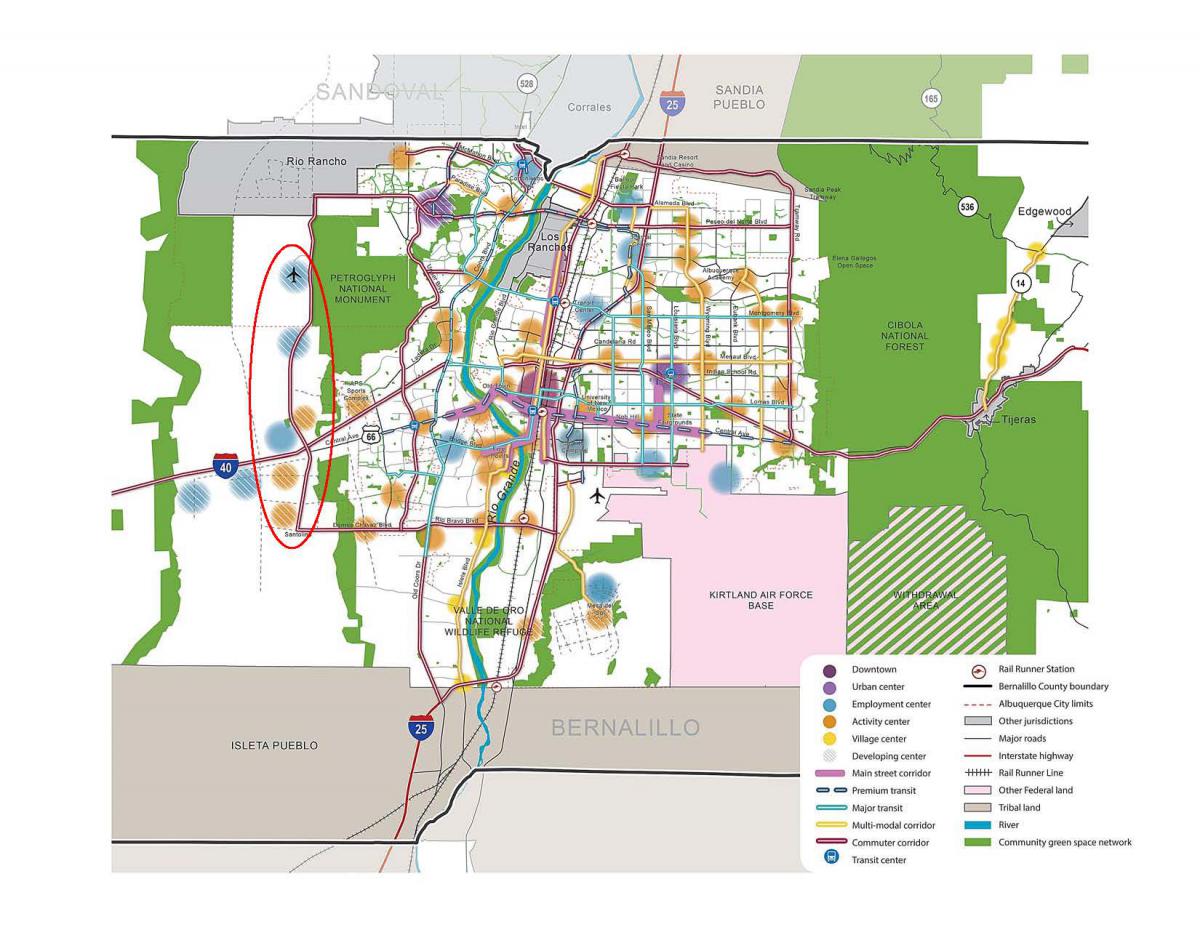
No. All but one of the Activity Centers on Atrisco Vista Blvd. (formerly Paseo del Volcan), sometimes referred to as the “string of pearls”, have been in the Comprehensive Plan since Centers and Corridors were first adopted in 2001. The other center was adopted by the County as part of a Sector or Area plan process and added to the Centers and Corridors map during a Comp Plan amendment in 2013.
Since the adoption of the Centers and Corridors in 2001, the name of the road in question changed from Paseo del Volcan to Atrisco Vista. A new roadway, to be located farther to the west of Atrisco Vista near the Rio Puerco escarpment, is under consideration and is proposed to take the old Paseo del Volcan name. This proposed right-of-way is reflected as a dotted line in the most recent Metropolitan Transportation Plan – Futures 2040 – and therefore also shows up on the proposed Vision map for the Comp Plan as a future roadway. No Centers are shown there.
The Centers and Corridors vision was an outgrowth of the Planned Growth Strategy adopted in the early 2000s. It was generally intended to provide an alternative to sprawling residential development with a strategic framework of mixed-use activity centers connected by a network of multimodal transportation corridors. Providing centers intended primarily as business parks and job centers was also part of a strategy to address the imbalance of jobs and housing on the West Side that has led to increasing traffic congestion on the region’s limited river crossings.
Centers and Corridors were first adopted as Figures in the Comprehensive Plan in 2001 by Resolution R-01-344. Almost all of the Activity Centers shown on these maps had been previously envisioned or designated by previous planning efforts, such as the West Side Strategic Plan (available here), which showed existing and proposed community and employment centers on what was then called Paseo del Volcan when it was adopted in 1997 (See Community Map, Page 29; Proposed Network of Southwest Albuquerque Activity Centers, page 148, etc.). You may view the Centers and Corridors Map as it was adopted by the City and County in 2001 by clicking here.
The Centers and Corridors amendment in 2013 (Resolution R-13-172) incorporated policy adopted by the City and County since 2001, such as the adoption in 2009 of the Southwest Albuquerque Strategic Action Plan (SWASAP) and the establishment in 2011 of the Volcano Mesa Community Area, which designated new Activity Centers near the intersection of Unser and Paseo del Norte. The only changes made to Activity Centers on Atrisco Vista by the 2013 amendments were changing two activity centers at Central/I-40 from “developing” to “existing” and the addition of one Community Activity center in the County at Dennis Chavez/Atrisco Vista, which had been adopted by Bernalillo County as part of a Sector Plan. Additionally, two Activity Centers in Quail Ranch were actually removed from the Comprehensive Plan via R-13-172 because that area had been annexed by Rio Rancho. You may view the Centers and Corridors map adopted as of 2013 here.
Developments are reviewed against adopted plans and regulations that are in place when they are submitted.
Santolina, the proposed master planned community on the southeast mesa, received approval of its Level A Master Plan from the Bernalillo County Commission based on policies adopted in the 2013 Albuquerque-Bernalillo County Comprehensive Plan. It is important to note that development will require approval of the Level B and Level C plans, and details will be determined through that review and approval process by the County and reviewed against whatever adopted plans and regulations are in place for each of those submittals.
For information and updates about Santolina, please visit this County website: http://www.bernco.gov/planning/proposed-santolina-level-a-master-plan.aspx .
Santolina is raising incredibly important questions about our future growth patterns, and those discussions will be at the heart of community conversations for a long time.
Updates to the Comprehensive Plan provide opportunities to look at the kind of development proposed for Santolina and make changes to goals and policies that would apply to future proposals.
Development Areas were mapped in 1975 with the first Comprehensive Plan.
The County continues to use the original designations (Central Urban, Established Urban, Developing Urban, Semi-rural, and Rural) within the unincorporated County. (See Figure 5-5 in Chapter 5: Land Use in the 2017 ABC Comp Plan.)
Within the city, these 1975 Development Areas were not changed or adjusted over time, despite 40 years of development, and they became increasingly irrelevant and ineffective in guiding new growth. The 2017 update replaced the original Development Areas in the city with just two complementary areas:
- Areas of Change, where growth is expected and encouraged, and
- Areas of Consistency, where new development is to respect and reinforce the scale, intensity, and character of the existing context.
By directing growth to Areas of Change, existing neighborhoods and open spaces can be protected from the potential negative impact that would result from having to absorb too much growth. Coupled with policies to encourage appropriate transitions from and buffers between these areas, the Areas of Change and Consistency map is intended to be an effective tool to implement Centers and Corridors and protect existing neighborhoods.
Areas of Change (shown in ORANGE in the map below) include Centers and Metropolitan Redevelopment Areas with adopted Metropolitan Redevelopment Area Plans, properties along transit and multi-modal Corridors, and properties with adopted Master Development Plans for business and industrial parks.
- Areas of Change: The intent is to focus or direct development to areas with infrastructure that can support additional density, etc. This will help accommodate new residents and jobs in the existing built area of the city where they can be served by transit (as an alternative to sprawl); help support redevelopment of commercial corridors (providing services, stores, etc. to neighboring communities); and protect and enhance existing single-family neighborhoods.
- Areas of Consistency: The intent is to protect single-family neighborhoods, Open Space, parks, golf courses, cemeteries, and airport runways from development that is too dense or out of scale or character of the existing context. While properties can still develop in Areas of Consistency, the scale and design would need to be respectful of the scale and character of surrounding single-family neighborhoods.
The Comp Plan policies guide development requiring a zone change and new regulations adopted over time. In the City's Integrated Development Ordinance, zoning regulations limit the scale of development and enhance buffering in Areas of Change abutting Areas of Consistency as an added protection for single-family neighborhoods.
See also:
Actions are to-do items for the City or County. They are not automatic and will require additional action by the local governments. For the City, many of the Actions foreshadow work to be accomplished through new or revised regulations in the Integrated Development Ordinance. For the County, actions may take the form of future planning efforts for Area Plans or Sector Development Plans for specific locations. Advocacy by members of the public to decision-makers for actions that they think should be priorities is almost always necessary and helpful.
The Millennial generation - those born between 1980-2000 or so - has a bigger population than the Baby Boom, which has shaped the U.S. market since the 1960s. Due to sheer numbers -- and to different preferences, lifestyles, and timeline for life milestones -- the Millennial generation is worthy of consideration for future planning efforts.
No generation is monolithic, so of course, trends are just about averages and not about everyone. That said, we are seeing the Millennial generation make different choices on different timelines than people in previous generations. On average, they have a bigger preference for transit; less interest in driving or owning cars; more interest in walkable, urban districts where they can live, work, play, and learn; and more interest in renting or living at home for longer while in college or just after graduation. They are also putting off marriage and kids until later in their lives. Some retiring boomers and pre-family "Gen X" individuals are increasingly wanting these options, too.
In Albuquerque, we have a large housing stock of single-family homes in walkable areas that can serve future interest in homeownership for this generation. Master planned communities and suburban development are also expected to efficiently meet market demands for single-family homes into the future.
What we will struggle to provide is enough rental units and enough urban housing options for Millennials who may want those choices now and in the future. While the percentage who want these options will remain small, taking a small percentage of a very large number may mean that Albuquerque does not have - and will not have without intervention - enough housing of this type to meet demands, particularly when other small percentags of other generations may want the same kinds of choices.
Providing higher-density housing in activity centers and as infill in already-developed areas proves challenging for developers. The Comp Plan Update spends time addressing these challenges to make sure we are broadening housing options to meet growing demands into the future.
The 2017 ABC Comp Plan was based on the forecast from the Mid Region Council of Government's Metropolitan Transportation Plan for 2040, which anticipated 311,000 new people and 132,000 new jobs. This forecast was based on steady trends in our region.
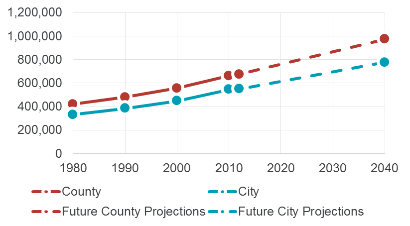
The anticipated rate of slow, steady growth gives us plenty of time to put plans in place, track them, and make adjustments over time, if needed. Most Comp Plans are reacting either to a huge growth spurt, causing many unanticipated issues, or a big lag in growth, which also comes with many negative impacts. Absent of these pressures, we have the chance in our Comp Plan to contemplate how we want to grow steadily over time, and where the majority of that growth should go, and how to put infrastructure and programming in place to avoid negative impacts and extend positive benefits.
When the Comp Plan is updated again in five years, the Mid-Region Council of Governments will have developed a new forecast for its next Metropolitan Transportation Plan, and the Comp Plan will be adjusted accordingly.
One of the most important things that a Comp Plan needs to do is make clear where growth should go and what areas should be protected.
The updated Comp Plan is neither a pro-development plan nor an anti-growth plan. During the public engagement effort for the 2017 update, some community members questioned whether the Plan needed to acknowledge or plan for growth at all. But planning for growth and identifying where it is most appropriate is the primary purpose, responsibility, and power of a Comprehensive Plan. Acknowledging growth or density does not make the Comp Plan developer-driven. It makes for a strategic plan that can help us balance where to grow and what to protect so that we can keep Albuquerque unique even as we grow.
The 2017 update acknowledges that Albuquerque is continuing to grow even as the state loses population, so the Comp Plan must answer this question:
- If we continue to grow to 2040, where is growth most appropriate?
Since 2001, the Comp Plan has said that growth is most appropriate in Centers and along Corridors. This update continues that vision for growth.
But it goes further than the 2013 Comp Plan in identifying in greater detail where growth should NOT be encouraged – in neighborhoods and historic areas, in rural and agricultural areas and acequias, and in Open Space. These areas are mapped as Areas of Consistency.
- It is important to note that not every apartment or commercial property is included in Areas of Change. Those that are NOT in a Center or along a Corridor or in an MR Area – all places where adopted City policy says that growth and redevelopment are to be encouraged – remain in Areas of Consistency, and they can develop based on their existing zoning and entitlements. This is intended to make clear where ADDITIONAL growth should be absorbed to guide future zone change requests.
The former Development Areas – Central Urban, Established Urban, and Developing Urban – were mapped in 1975. Historic and special places and neighborhoods were not specifically mapped in the 2013 Comp Plan. The 2013 Comp Plan had some general policy language about what to protect, but it was largely lacking in detail, and provided little direction to decision-makers about where zone changes to more intense development are appropriate.
The updated Plan maps these areas as Areas of Consistency and adds policy protections affecting neighborhoods and Open Space from Rank 2 Area Plans and Rank 3 Sector Plans, extending the same protections to ALL communities, where only SOME were protected by Sector Plans prior to the 2017 update.
We are thankful for the comments and participation from the community and agency and department staff throughout the update process, and particularly during the 9 months of the official review and approval process. As you can see in the redlines and greenlines and Floor Amendments, the project team listened closely to the community for ways to improve the draft. The adopted Comp Plan is a much better Plan than even at the beginning of the public review period, and particularly better than the 2013 Comp Plan, because of public engagement and comments.
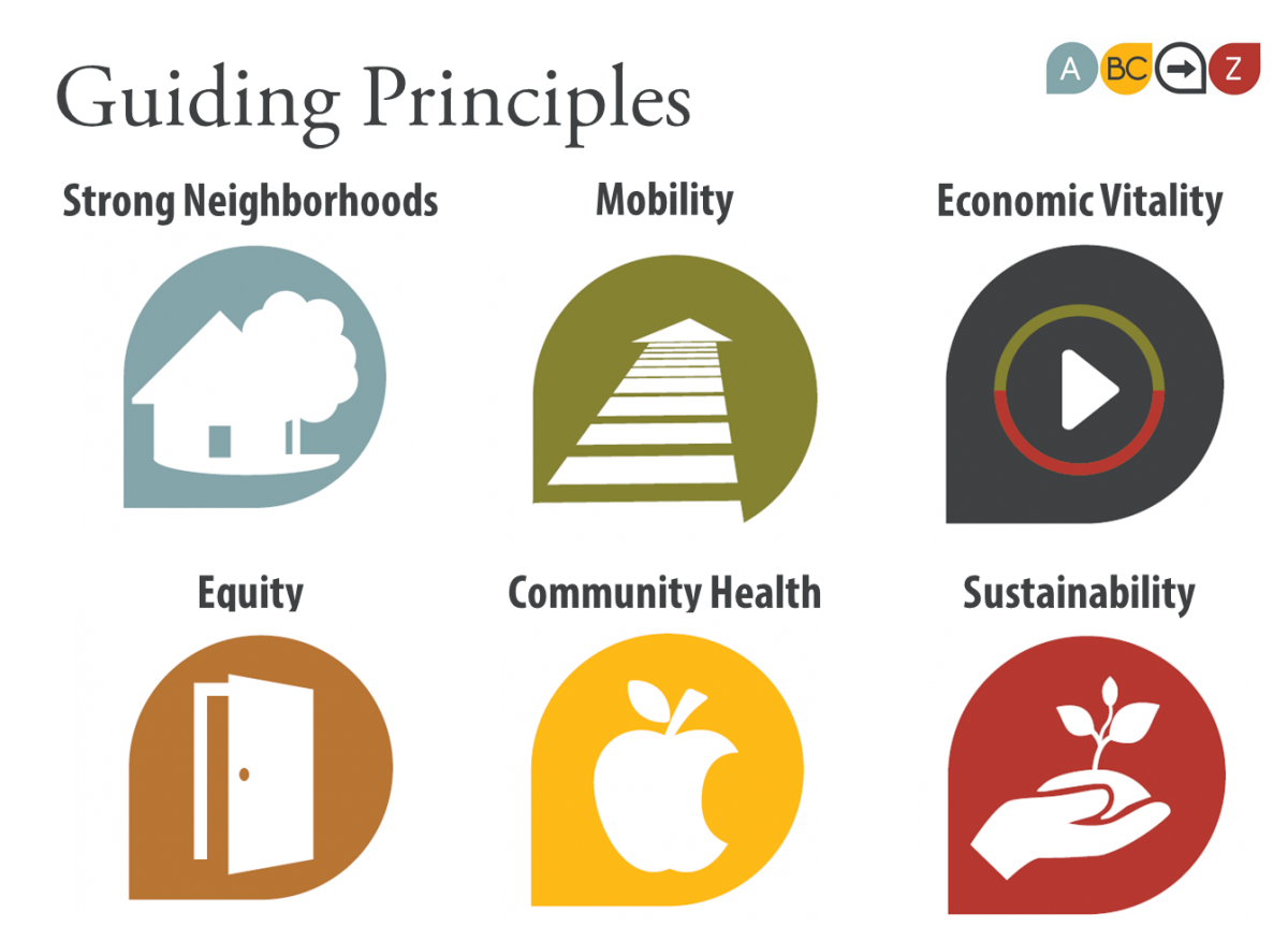
The updated Plan adds Guiding Principles for Strong Neighborhoods, Mobility, Economic Vitality, Equity, Community Health, and Sustainability. It adds discussion and protections for Environmental Justice and acequias, which were completely lacking in the 2013 Comp Plan. These are not developer-driven values, but rather those expressed by the community throughout the public engagement effort.
We hope that the more people use the Plan, neighbors will discover for themselves the ways in which it is better, stronger, and more relevant to the issues that most communities face. Adopting this Comp Plan added protections for communities that lacked them. That reason alone is worth celebrating an updated plan.
The Planning Department will continue to maintain a version of the Comp Plan that includes footnotes and endnotes that work together with a Matrix of Adopted Policies from Area Plans, Sector Plans, and Corridor Plans.
We all want to be protected. We all want to see our vibrant neighborhoods and special places protected. The updated Plan indicates where to direct growth in order to protect what we all value – our distinct and historic neighborhoods, our Open Space, and our acequias and rural areas.
The project team reviewed the existing Comprehensive Plan, the City's Rank 2 Area Plans, and the City's Rank 3 Sector Development Plans to analyze how well they work, identify overlaps and duplication, and integrate effective goals and policies into the Rank 1 Comprehensive Plan. The intent is to eliminate outdated, overlapping, and/or duplicate goals and policies between plans, where possible and advisable, and incorporate any area-specific goals and policies into the Comprehensive Plan, including geographic-specific sections for special places.
One of the main goals of the Comp Plan update is to revise goals and policies to coordinate with the latest transportation planning done by the Mid-Region Council of Governments through its Futures 2040 efforts to update the regional Metropolitan Transportation Plan.
A member of the consultant team, Fregonese Associates out of Portland, Oregon, led the update to the Comprehensive Plan. Another member of the consultant team, Clarion Associates out of Denver, Colorado, is performing a similar analysis of existing land use regulations from the City's multiple standalone plans – looking for overlaps, conflicts, and regulatory approaches that are ineffective or out-of-date. Those controls that can be consolidated, where possible and advisable, and those unique to specific areas will be incorporated into one regulatory document that is easier to understand and better illustrated – an Integrated Development Ordinance.
Public Engagement
Public engagement was conducted in several rounds to develop the content for the updated Comp Plan.
- A full list of ABC-Z meetings is available for review here.
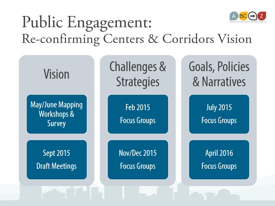
ABC-Z Kickoff & Focus Groups - February 2015
A series of focus groups were held by topic to discuss challenges and strategies.
- Meeting Materials
Visioning/Mapping Workshops - May & June 2015
Two county-wide visioning workshops were held in May 2015, and four meetings - one in each quadrant of the city - were held in June 2015.
- Presentation
- County-wide Visioning Map Results
- Survey/polling Results
July 2015 Focus Groups
A series of focus groups were held by topic to discuss goals/policies, implementation/action, coordination, and key considerations.
- Presentations & Notes
September 2015 Vision Draft Open Houses
The project team hosted several open houses to review the first draft of the Community Vision chapter.
- Presentation
- Monday, September 21, 2015 - 1:30pm to 3:00pm - Central & Unser Library
- Monday, September 21, 2015 - 6:00pm to 7:30pm - Alamosa Community Center
- Tuesday, September 22, 2015 - 1:30pm to 3:00pm - Downtown Library
- Tuesday, September 22, 2015 - 6:00pm to 7:00pm - Hiland Theater
Nov/December 2015 Focus Groups
These meetings were organized by Comp Plan Chapter to provide more in-depth opportunities for discussion by topic. County staff also hosted meetings focused on County topics and issues in December 2015.
-
Comp Plan Draft Meetings
-
Meeting Materials
April 2016
The project team held a series of meetings focused on the following chapters:
Drafts
The project team finalized a complete draft update in January 2016 for public review at a series of public open houses.
Public Open Houses - January 27 & 28
- Posters
- Presentation
The project team incorporated public input from April 2016 into a second draft in May 2016.
The project team made final edits and submitted the EPC draft in June 2016.
City Review/Approval Process
The ABC Comp Plan was reviewed beginning in August 2016 and adopted in April 2017
NOTE: These are no longer the most recent drafts of Comp Plan Chapters!
The project team subsequently incorporated graphics, consolidated goals and policies, and responded to public and staff comments in a revised draft in May 2016. A final draft was submitted to the City's formal review and approval process in June 2016.
The first draft of the Comp Plan Update was posted for public review in January 2016.
This first draft was intended to accomplish the following:
- Update information about relevant existing conditions
- Better coordinate land use and transportation
- Better reflect the importance of preserving agricultural heritage, including acequias
- Provide guidance to update the City’s zoning code through the Integrated Development Ordinance
- Incorporate goals and policies from the City’s existing Rank 2 Area Plans and Rank 3 Sector Development Plans
- Better organize content
Open Houses were conducted on January 27 & 28.
- Presentation
Note :
[ABC] indicates a policy or action for both the City and County
[BC] indicates a policy or action for Bernalillo County
[A] indicates a policy or action for the City of Albuquerque
- Table of Contents
- Chapter 1 - Introduction
- Chapter 2 - Factors of Growth & Development
- Chapter 3 - The Vision
- Chapter 4 - Neighborhoods
- Chapter 5 - Land Use
- Chapter 6 - Transportation
- Chapter 7 - Urban Design
- Chapter 8 - Economic Development
- Chapter 9 - Housing
- Chapter 10 - Parks & Open Space
- Chapter 11 - Heritage Conservation
- Chapter 12 - Resilience & Sustainability
- Chapter 13 - Infrastructure, Community Facilities, & Services
- Appendix: City Area and Sector Development Plans
"In your opinion, what are the two (2) most important issues facing Albuquerque/ Bernalillo County?"

In your opinion, what are Albuquerque/Bernalillo County’s two (2) greatest strengths?
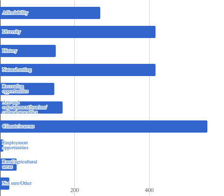
May County-wide Workshop Results
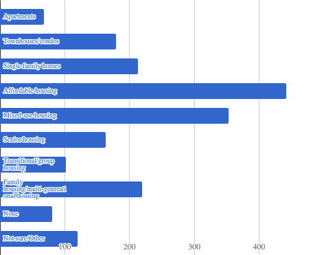
"What types of housing are most needed in Albuquerque/Bernalillo County?"
City Council's Land Use, Planning, and Zoning (LUPZ) Committee Public Hearings
The ABC Comp Plan update was heard by LUPZ at two hearings in November and December 2016. LUPZ voted to move the Comp Plan for consideration by the full Council with no recommendation.
- Hearing #1: November 16, 2016
- Spreadsheet of Staff Responses to Written and Public Comments as of December 7, 2016 for LUPZ consideration
- Staff presentation available here.
- YouTube Video posted here by Edward Tavasci.
- Hearing #2: December 14, 2016
- Spreadsheet of Staff Responses to Written and Public Comments as of December 7, 2016 for LUPZ consideration
- Proposed Substantive changes for Greenline draft
- Proposed Editorial changes for Greenline draft
- Proposed Clerical changes for Greenline draft
- Staff presentation
- Handout - Existing Comp Plan policy pages
LUPZ Redline Draft
- Chapter 1: Introduction
- Chapter 2: Factors of Growth & Development
- Chapter 3: Vision
- Chapter 4: Community Identity
- Chapter 5: Land Use
- Chapter 6: Transportation
- Chapter 7: Urban Design
- Chapter 8: Economic Development
- Chapter 9: Housing
- Chapter 10: Parks & Open Space
- Chapter 11: Heritage Conservation
- Chapter 12: Infrastructure, Community Facilities, & Services
- Chapter 13: Resilience & Sustainability
- Chapter 14: Implementation
- Appendix
Policy Matrix - LUPZ Draft
A spreadsheet with existing policies from the 2013 Comp Plan, City Area Plans, and City Sector Development Plans is online here.
- Where existing policies are reflected on policies in the Comp Plan Update, a footnote appears, which refers to endnotes at the end of each chapter that provide plan names and numbers in bracket that correspond to the row numbers in this matrix.
Following kickoff focus groups in February 2015 and Visioning Workshops in May and June 2015, the project team held 22 focus groups to discuss challenges and strategies by topic to develop content for the draft of the 2017 ABC Comp Plan.
July 2015 Focus Groups
Focus Group 1 - Land Use & Transportation
Focus Group 2 – LAND USE & TRANSPORTATION: Network, Hierarchy, & Modes
Focus Group 3 – LAND USE: Activity Centers
Focus Group 4 – LAND USE: Development Areas
Focus Group 5 – PARKS & OPEN SPACE
Focus Group 6 – COMMUNITY FACILITIES
Focus Group 7 – PUBLIC SAFETY
Focus Group 8 - HERITAGE CONSERVATION
Focus Group 9 - ECONOMIC DEVELOPMENT: Entrepreneurship / Small Business Development
Focus Group 10 - ECONOMIC DEVELOPMENT: Workforce Development
Focus Group 11 - TRANSPORTATION: Transit Coordination
Focus Group 12 - IMPLEMENTATION / CIP
Focus Group 13 - Utilities
Focus Group 14 - ENVIRONMENTAL: Energy Conservation
Focus Group 15 - LAND USE: Environmental Justice / Community Health
Focus Group 16 - LAND USE - Small Area Planning / Community Planning Areas
Focus Group 17 - ENVIRONMENTAL: Sustainability / Resiliency
Focus Group 18 - ECONOMIC DEVELOPMENT
Focus Group 19 – HOUSING: Existing Planning Efforts / Coordination
Focus Group 20 - HOUSING: Affordable Housing
Focus Group 21 - HOUSING: Mixed-Use / Redevelopment / Infill / Gentrification
Focus Group 22 - HOUSING: Homelessness
Within the City, the overall goal is to protect and maintain neighborhood character by integrating neighborhood-level goals and policies from standalone sector development plans into the Comprehensive Plan so that they help protect ALL neighborhoods in the city. By incorporating these policies into one policy document for the whole city, the Planning Department can administer and implement these policy protections more easily and effectively.
Goals and policies for neighborhood character (from existing sector development plans) have been integrated into the Comprehensive Plan so coordination can happen at a city/countywide level to achieve goals of individual neighborhoods and districts in a way that also contribute to realizing the vision for the broader community. See the Policy Matrix and summary handouts for each Sector Plan to see where adopted policies were incorporated in the 2017 Comp Plan update.
The adoption of the 2017 Comp Plan update did not affect adopted Sector Development Plans, but the subsequent adoption of the Integrated Development Ordinances replaced all sector plans with one integrated document. See also: Frequently Asked Question for ABC-Z - What will happen to the City's Sector Development Plans?
No. Neighorhood boundaries and names are not established by or affected by the Comprehensive Plan. Each neighborhood establishes its own name and boundary as part of the process to be recognized by the City, via the Office of Neighborhood Coordination. The Neighborhood Recognition Ordinance (sometimes referred to as O-92) establishes this process. The Neighborhood Recognition Ordinance is not part of of the ABC-Z project and is not intended to change in the foreseeable future.
See also: What are Community Planning Areas?
In the 1990s, the City had a planning effort that culminated in a Community Identity Report that mapped the city into 10 Community Planning Areas and created Blueprints for Action for many of the areas before the effort stalled out.
The Community Planning Area map was adopted into the Comp Plan in 2003. The Community Planning Area boundaries were adjusted slightly in 2017 to better match U.S. Census and City/County boundaries, the City's West Side areas were broken into three community planning areas, and County areas were added to the map.
Community Planning Areas are mapped and described in Chapter 4 Community Identity, and Chapter 14 Implementation and Appendix E describe the way that long-range planning with each community will happen in each Community Planning Area during every 5-year cycle of assessments.
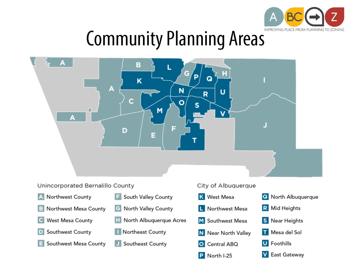
For more details on this process, see the Community Planning Area website:
The Comp Plan designates three Premium Transit Corridors:
- Central Ave.,
- Paseo del Norte, and
- University/I-25/Jefferson Blvd.
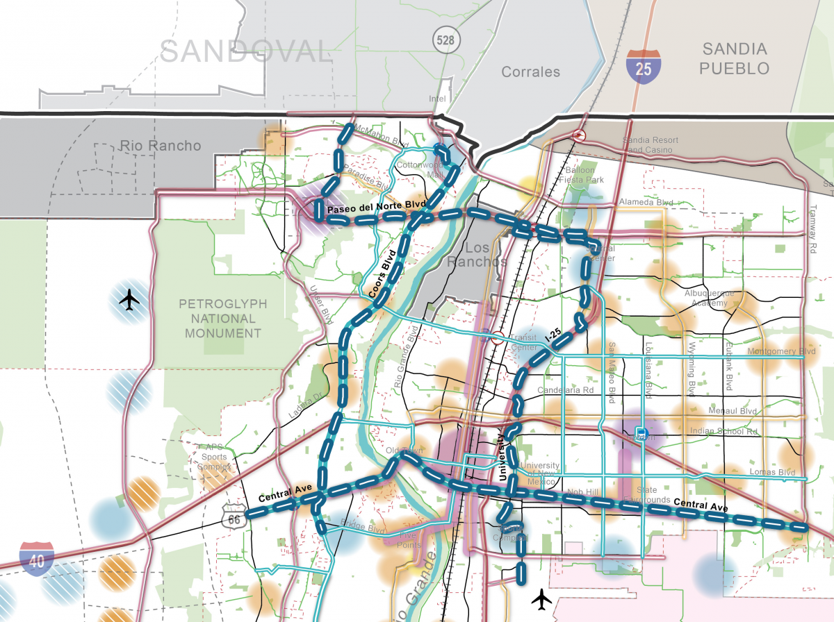
[NOTE: Coors Blvd. was removed by Council before the ABC Comp Plan was adopted in March 2017]
The Premium Transit designation signals an intent to plan the highest-quality transit service by the year 2040, typically with a dedicated transit lane. River crossings are congested now and intended to get more congested over time. The choice of corridors and dedicated transit lanes are intended to provide two options to cross the river by transit to reach key employment areas.
- On Premium Transit Corridors, within walking distance of transit stations, the Comp Plan encourages additional density, intensity, and more pedestrian-oriented developments.
- The Integrated Development Ordinance (IDO) implements this policy through allowing additional building height within 660 feet (1/8 of a mile) of Premium Transit stations, once they are identified.
- See Table III for an index of Center & Corridor provisions in the IDO.
- See Interactive IDO zoning map for PT areas, available under Button 2.
- See Section 7-1 Measurement Definitions for "Premium Transit (PT) Area" under the category "Corridor Areas" for how to measure PT areas.
- See Section 7-1 Center and Corridor Definitions for Premium Transit (PT) Corridor.
See also:
Transit station locations and spacing are identified during the process to plan a specific transit service on a corridor.
While all Premium Transit Corridors should incorporate dedicated transit lanes, the character and design of the road and the location of stations will vary among corridors depending on current and future land uses, roadway access policies, and underlying Comp Plan Corridor designations.
Other factors that are considered in deciding transit station locations include:
- Spacing between stations
- Key ridership generators / destinations (existing and planned)
- Intersecting transit routes
- Bike routes
- Pedestrian crossings, pedestrian facilities
- Existing ridership (assuming the Premium Transit is building on existing transit service)
- Right-of-way widths and physical characteristics of the roadway
Until Premium Transit is planned on a corridor, policies and regulations related to the underlying designation apply.
How will ABC-Z protect the character of Nob Hill within the Central Ave Premium Transit CorriHow will ABC-Z protect the character of Nob Hill within the Central Ave Premium Transit Corridor?
The Integrated Development Ordinance brings in architectural building design standards from the adopted Nob Hill Sector Development Plan as a Character Protection Overlay (CPO-5), which limits the applicability of higher building height allowances that would normally be allowed in Main Street and Premium Transit Corridor areas to be consistent with building heights allowed by the Nob Hill Sector Development Plan.
SU-2 CCR-1 and CCR-2 zones are proposed to convert to the MX-M in the IDO, which has a base building height limit of 45 feet, with 65 feet allowed in Main Street and Premium Transit areas.
- “Lower Nob Hill” (Girard to Aliso):
- Higher building heights associated with Main Streets and the Workforce Housing bonus are not applicable. This caps building heights at 45 feet or 3 stories in MX-M (consistent with 3 stories allowed in the Nob Hill Sector Development Plan Plan) .
- Building heights associated with Premium Transit areas are limited to blocks adjacent to transit stations.
- “Upper Nob Hill” (Aliso to Graceland)
- Higher building heights associated with Main Streets are not applicable. The Workforce Housing bonus allows an additional 12 feet on top of the 45 feet available in MX-M, which would result in building height of 57 feet or 4 stories, consistent with 4 stories allowed in the Nob Hill Sector Development Plan).
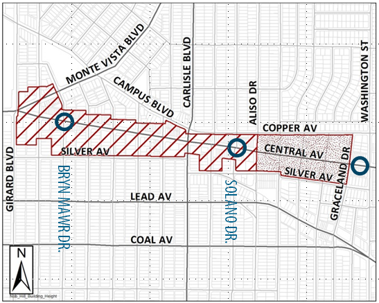
SU-2 CCR-3 is proposed to convert to MX-H, consistent with the Metropolitan Redevelopment Plan for this area east of Washington. Main Street, Workforce Housing, and Premium Transit bonuses for building heights would apply.
- Additional residential density brings more potential riders within walking distance of transit stations. Inconvenience is a significant barrier to transit ridership; convenience is a significant incentive. Let’s be real: If you have to get in your car to get to transit, you’re much more likely to decide to drive the whole way! If it’s easier to walk to transit (or cheaper to buy a transit pass than pay for parking), then you’re much more likely to use transit.
- Tall buildings can make pedestrians feel safer. Urban design teaches us that people like being in spaces that simulate the space on the edge of a forest and a savannah: You’ve got protection to your back and a vista on the other side. Translated to street sections, an ideal ratio of 1:3 height-to-width is what has been found to make people feel comfortable when walking. (See figure below from the adopted Nob Hill Sector Development Plan for an illustration.)
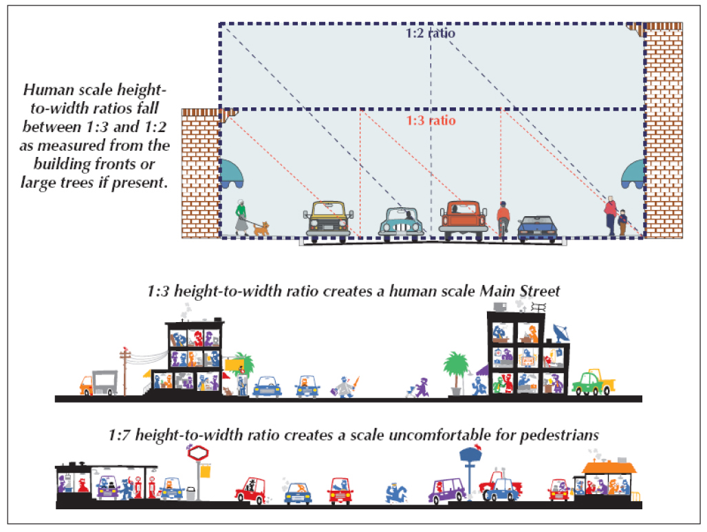
This means that to be a place that is pedestrian-oriented or human-scaled, the space between the buildings, including the road, can be up to three times as wide as the buildings are tall. Wider roadways require taller buildings to achieve the same sense of a “street wall” of buildings that people like to walk next to.

- Active areas with lots of things to see and do encourage pedestrians, slow cars, and help support transit. Encouraging higher-density and higher-intensity development near transit encourages lots of activity. People and businesses like to be in places with lots of activity, and lots of people walking and enjoying a place is part of what makes great places. Planners talk about this as “activating” spaces, a fancy way of saying – make places where there are things for people to do and a built environment that welcomes them and that they can love!
- Parking lots are not very active, exciting, welcoming places for people to be. A sea of parking sends a signal that people who drive are welcome, and people who walk are less important. Parking is often a large expense for a development project. Requiring less parking is meant to provide an incentive for businesses that are less auto-oriented to gravitate toward places where less parking is required. This also leads back to the convenience of driving versus transit. When it gets harder to find parking, it gets more convenient to take transit! This is a mutually reinforcing dynamic that helps the businesses that help support transit, which helps all of us by increasing the viability and feasibility of walking, biking, and transit.
- More dense and taller developments help turn what could be just a parking lot into a building. Permitting taller heights helps redevelopment projects “pencil out” by allowing a developer to build the number of units it will take to cover their mortgage on development loans, meet square footage requirements of affordable housing incentives, and in constrained areas, provide room for lower-level parking within a building footprint. This helps drive investment and redevelopment, especially in areas of the city where lower land prices, outdated structures, and lack of demand for retail space have resulted in extended vacancy.
